Sunday, 3 May 2009

Whiteside, Hopegill Head, Grisedale Pike

We had a terrible nights sleep. The tent next to us decided to light an open fire right near our tent so we ended up breathing in all of the smoke. Poor little Molly was coughing and sneezing. Then Niki was sick in the middle of the night. Then Molly escaped under the bottom of the tent and got me into trouble with the campsite owner!!

Apparently Scott and Helen also had a rubbish night’s sleep and therefore, decided to have a quiet easy walk on their own.

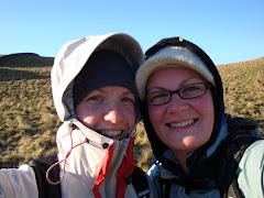
So Niki and I decided on our route for the day. We drove from our campsite to the top of Crummock Water and headed up Whiteside. Wow, this is by far the most testing fell that either of us had walked on so far. It was literally a scramble / climb up a steep, rocky, craggy side for about 45 minutes. Had we not seen people going up before us, we would definitely have thought we were going in the wrong direction. Then two men came down the way we were going, so it was a case of “it’s the right way, we just have to keep going”. Molly is so funny on this kind of terrain; she goes off ahead with absolutely no worries. Every now again when you look up you will just see her looking back down and you can see her thinking “come on mummy’s what are you waiting for”.

Anyway we eventually got to the top, and we had fabulous views of the Scottish mountains over the Solway Firth (the best yet) but we saw the way to our next fell (Hopegill Head) which was a really narrow ridge with massive drops on either side. Now I’m sure it was nothing compared to Sharp Edge or Striding Edge, however, it was a big deal for us. Niki was really nervous, as she isn’t great with heights! But we set off and just took it really slowly. On the way we got talking to a really nice couple from Derbyshire who had 2 Springer Spaniels, one of them was a really cute puppy. She was on her lead because apparently she tried to chase a bird the day before and nearly jumped off the side of a fell (High Street). It was kind of nice to follow them because they seemed far more confident with the terrain than us! The summit of Hopegill Head is very impressive, sat on the side of a steep drop down with a really craggy top.

We then made our way over to Grisedale Pike and the wind and cold really picked up. I was wearing; my walking trousers, waterproof trousers, a short sleeved base layer, long sleeved base layer, a jumper, a wind-stopper jumper, a waterproof coat, a hat and my winter gloves and I was still cold. Grisedale seems to get all the wind an cold blowing off the Atlantic and we were really starting to fail! When we got to the top we found a sheltered part out of the wind and it was really lovely, we sat for about 10 minutes looking at all of the Lakeland fells to the East.

We eventually set off back towards the direction of the car, but we knew that all of the hard walking we had done today was waiting for us in reverse order. We eventually made it back and although we had only covered 7 miles all day, it was definitely the most difficult and testing walk we had done to date.


7 miles

Saturday, 2 May 2009

Whiteless Pike, Wandhope, Grasmoor, Eel Crag, Sale, Rannerdale Knotts

After arriving in the Lakes late on Friday evening with our friends Scott and Helen we pitched up camp and spent a very cold first night in our new tent.

On the Saturday we planned a long walk, which incorporated quite a few Wainwright’s. Our plan was to head for Rannerdale Knotts, however, we took the wrong path from the car, so we decided to head straight for Whiteless Pike and go to Rannerdale on the way back. The path took us along a very scenic route up by the side of a stream gradually climbing upwards. After a while we deviated away from the stream and the ascent got a little steeper, in fact we commented that it was a mountain that just kept taking……………..every time we thought the summit was in sight a further summit would appear in the distance. Scott and Molly went off ahead and we all eventually made it to the real summit.

It was extremely cold at the top and we saw that to reach the summit of our next fell (Wandhope) we had to cross a ridge that looked extremely exposed to the wind. So we took a few moments to put some more layers on. The ridge actually looked a lot worse than it actually was and in no time at all we seemed to be at the top of Wandhope, were we found some shelter from the wind and stopped to have some lunch.

It was at this point that Niki decided that we could easily complete another 3 peaks that were in close distance, along with Rannerdale on our way back. So after lunch we headed up towards Grasmoor, this is the largest fell in Wainwright’s North Western book and it did look mighty grand sitting in the background. To say that it is quite a big fell, it was actually quite a pleasurable journey to the top, then there’s long flattish top, which you have to walk along to get to the true summit.

We then made our way down to Eel Crag, which had some spectacular views. However, Scott was scared to death looking down over the edge as he had a weird urge to jump!!!! So we didn’t stick around for long and made our way over to Sail. This again was an easy gentle walk, however, we kept getting held up by a group of 40 people on an organised trip and we spent the whole time trying to lose them!

On our way down from Sail we stopped for a picnic on the side of a sheltered slope and were passed again by our friends on the trip. All of these people seemed to think that Molly was lovely and at one point we lost her as she decided to go off with them because they were eating (very embarrassing!)

Our final ascent was up Rannerdale and this was a really nice little fell. There was a little bit of climbing involved, and a great view of the fells that we had done today. Then we made our way back to the car and Niki got talking to the man who was the leader of the organised group. He apologised for getting in our way all day and he gave Molly a chocolate berry. All was forgiven


10 Miles

Sunday, 19 April 2009

Whernside and Inglebrough


Bit more 3 peaks training today. Scott and Helen joined us in a walk fromthe Ribblehead viaduct, up Whernside, back to the Hill in, up Inglebrough,then back to Horton in Ribblesdale.

We left our car in Horton, then the 4 of us drove to the Ribbleheadviaduct. The weather was absolutely glorious and we made our way towardsWhernside (the last time we did this walk we spent so much time walkingbackwards and forwards trying to find the right path, so it was quite anice change to head straight up the fell). We made really good progress tothe top and when we got there the views were amazing and there wasn't abreath of wind.

Making our way back down Helen and Scott started to apply the factor 30 asthe sun was really strong. We again made really good progress to the HillInn which was probably helped by the fact that this is the 5th time we'vedone this leg this year.

Next was the trip up Ingleborough. A really nice walk through greenfields, but the sheer face of Ingleborough is looming in the background andwe were wondering how the hell you get up there. Then we saw the zig zagpath up the side and my god it was steep! So we stopped for a quick snackand a drink of water before making our ascent. It's a real climb up thereso you're not actually thinking about the fact that it's exhausting becauseyou're always looking where to put your feet and hands next. But it feltlike a real achievement when we got to the top, where we stopped to take aquick photo.

The path back down Ingleborough to Horton was lovely. It was all downhill (at a very slight decline all the way) taking in some really lovely countryside. I wonder what we'll think of it on the actual day!


15 miles

Sunday, 12 April 2009

Dale Head, Hindscarth and Robinson

After a terrible nights sleep (long story, it was minus 3 and we were pitched next to a group of boys who only had one volume setting on their car stereo.........very loud).

We drove down the Honister Pass towards Buttermere lake and stopped at the road side next to the Honister slate mine (which is the only working slate mine left in the UK) as this was the start of our walk today.

As we'd had a terrible nights sleep, we both found it really hard work today, we were both absolutely exhausted. But on the positive side the weather was beautiful again with bright sunshine and not a cloud in the sky. The long hard walk up the fell was worth every last ounce of energy.............it was without a shadow of a doubt our favorite view so far. To the North there were excellent views of the Northern fells including Skiddaw and Blencathra. To the North West we could see the coastline (the Solway Firth) and beyond that we could see the Scottish Mountains. To the West you could see Buttermere Lake and Haystacks (Wainwrights favorite mountain and the one where his ashes are scattered). Then to the South and East the other mountains of Lakeland.


After taking in this view for a while we made our way over to Hindscarth and when we reached the summit here, the sun was so warm we stopped for a lay down for 10 minutes!! Then over to Robinson, which included a massive decsent followed by another large ascent. You could see the coast line so clearly from here.

Then we made our way back the way we'd come (which included a great deal of decent and ascent), got back to the car. We then drove over to Keswick (which was packed with Easter weekend visitors) to our favorite bakery for some "nice things".

A fantastic weekend, can't wait for our next visit.

Saturday, 11 April 2009

Castle Crag, High Spy, Maiden Moor and Catbells

It's easter weekend. The weather forecast for the Lake District is appauling and we put off coming on Friday because it was raining at home.


We decided that as long as the weather wasn't too terrible, we were going to bite the bullet and go to the Lakes anyway. So Saturday morning arrived and we got up early and packed our camping stuff in the car and set off for the Lakes. The traffic was quiet and we got there in really good time.


We have now nearly completed all of the peaks in Wainwrights "Northern Fells" book so we decided to move onto the "North Western Fells" (we're saving the last couple of Northern Fells for our holiday in June as we're already booked back into our cottage in Bassenthwaite). We found a campsite near Buttermere Lake in the village of Seatoller, the views were beautiful.


We roughly planned a route close to where we were camping including Castle Crag (which Julia Bradbury covered in her TV programme Wainwright Walks). As we approached Castle Crag you could make it out immediately, quite small but very distinctive. The mountains in this area of the Lakes are so very different to what we are used to. Skiddaw and Blencathra are vast sloping mountains, whereas these are very craggy. Castle Crag was lovely but because it was a beautiful day (and because it has been on TV) the summit was really busy.


It was now midday and the sky was clear blue with not a cloud in site, it was warm and we were in such lovely surroundings.


We then decided to make our way up to High Spy, which was quite a long slog to the top, but we were rewarded with such lovely views. Then we had to decide whether to head West over towards Dale Head and Robinson or if to head North towards Maiden Moor and Catbells. After short deliberation we headed North and stopped at Maiden Moor, to take in the views. Much to Molly's delight a really nice couple who were sat taking in the views offered Molly a piece of chocolate orange (which made this Molly's favourite fell of the weekend).


Then we moved on to Catbells, which was quite a bit further than I had planned. (This is another fell that Julia covered in her TV series). This was also very busy.......in fact I think the M62 was quieter on the way over! I much prefer the quieter lesser known fells, you can enjoy them for their peaceful beauty.


Then to give Niki's poorly knee a bit of a rest we decided to decend at Catbells and walk back to Seatoller along a public footpath along the flat.


Then it was back to the tent for some scrummy food that Niki had made before we came, a nice cup of tea then early to bed.


So much for the rubbish weather forecast it's been such a lovely day.......maybe the rain will come tomorrow!

Sunday, 29 March 2009

Pen-y-ghent and Whernside

Our 3 peaks challenge is at the end of June, so we thought it would be a good idea to buy the official guidebook and make sure that the routes we have been following so far have been correct.

We thought that today we would do the Pen-y-ghent section of the route. I went into the cafe and had a massive dilema with all of the books and maps that they had about the walk. So we set off up Pen-y-ghent (the book confirmed that the way we had been previously was correct.) We whizzed passed everybody going up the hill as I think that our training in the Lake District had made our fitness improve a great deal. We were at the top within an hour and then set off back down again.

We were hoping that the book would take us a different way through the bog but unfortunately it didn't!!! But we found a less boggy part and made our way across the numerous fields and bogs towards the final farm and the road.

When we reached the road, we were both feeling so good that we decided to do the next section of Whernside. (again the book confirmed that the way that we had been previously was the correct way). So we stopped at the burger van on the road side to buy a couple of cans of Coke as we didn't have enough liquid and sugar to keep us going for a walk this long. We set off up Whernside and again we just felt on top form and very fit. We managed to keep going without stopping for any rests at all.

When we reached the summit of Whernside it was quite cold and windy so we didn't hang about we just wanted to get down and on our way. Unfortunately Niki's knee condition means that decents really hurt her and Whernside is particularly bad for her because it is very steep and it is in step format.

We made it down and headed back towards the road. We realised that on the road we had about another 8 miles to go. We started worrying about the amount of daylight we had left so we kept going at a quick pace.

The last 3 or 4 miles were absolute agony, we were really tired and I thought Niki wasn't going to make it as her knees were really bothering her. But we got back eventually for about 8.30 (Just before darkness). When we got home we just ate and went straight to bed.

21 miles!!!!!

Friday, 20 March 2009

Longlands Fell, Brae Fell, Great Sca Fell, Meal Fell, Great Cockup and Knott

When we set off this morning the mist looked like it might clear. We could just see Longlands Fell as we walked around the bottom of it and we could also see Brae Fell at the other side of the valley. But when we got to the top of Longlands we couldn’t really see much else, so we didn’t stick around for very long. We made our way back down and along to the head of the valley, then started to climb upwards, when we got to the top we were only a stones throw away from Great Sca Fell but we tracked back a little to get to the summit of Brae Fell. Again we couldn’t see a great deal so we continued on along the top to what we thought was Great Sca Fell, but it was in fact Little Sca Fell. So we headed upwards again until we got to the actual summit.

Here was a lovely place to sit and eat our sandwiches even though we couldn’t really see very much. Another couple appeared on the top from what appeared to be the direction of Meal Fell and they said that it was a very visible path and quite easy to achieve. So after we’d finished our sandwiches we headed in that direction. On our way over to Meal Fell the cloud lifted slightly and we could see the fells all around us for the first time all day. Once we reached the top we thought it looked quite achievable to head for Great Cockup (although it looked like a very steep down and up), so off we went.

We had estimated that it would take us about 45 minutes to get to the top of Great Cockup, but it was actually easier than it appeared and we had gone there and back in 30 minutes. On our way back the cloud descended again and unfortunately to get to Knott, (which was the next summit we were aiming for) we had to go back to the top of Meal Fell, then back to the top of Great Sca Fell. When we actually got there I thought I was going to have a heart attack, I was absolutely knackered. But we just had to get to Knott then we were going to head back to the car.

Knott is the highest Fell that we climbed today and as we approached, we started to walk out and above the cloud. It was amazing to look back and see a blanket of cloud behind us (that we had been walking about in for most of the day). At the top of Knott we could see Skiddaw, Blencathra and Great Calva really clearly. In fact the cloud only seemed to be in the valley that we had been in. After a little break to eat an apple we headed back over to Great Sca Fell and then back down through the valley to our car.

We really wanted to attempt Bakestall and Great Calva but we didn’t think we had the light to do it safely (plus all this cloud can be quite disorientating). So we headed back to our little cottage. The man who owns the cottage told us that Keswick had been baking in sunshine all day………….typical.

On the plus side, we’ve booked to come back to our cottage in the middle of June. Can’t wait!