We are doing the Yorkshire 3 Peaks Challenge in June with our friends Scott and Helen. So we are making sure that we walk as much as possible, so we're ready to walk 26 miles in 12 hours. Prior to the walk in June, we're also walking the 3 Peaks route in 3 sections to make sure that we know the correct route to save time checking maps on the day.
Most of these routes already appear in Wainwrights "Walks in the Limestone Country" books anyway.
We have already done Horton-in Ribbledale to Pen-y-Ghent over the boggy marsh ground back to the main road and then back to Horton. We did this about a month ago before I started keeping a blog of our walks.
Yesterday we did the second part of the route. Ribblehead, to Whernside back down to Ribblehead.
I was particularly worried about this leg of the challenge because I'd read previously that the scramble up the side of Whernside was particularly steep and it was a real "scramble" to the top. I'd also read about the route in Wainwrights book under walk 23.
However, I decided to follow the "official route" which is detailed on a website called merseyventure. These people take bookings for groups to take them round the 3 Peaks challenge so I thought it was a pretty safe bet to use this as a good route to follow.
We set off from Ribblehead and walked to the inn then took the footpath off down by the side of the Ribblehead viaduct. The weather was pretty terrible at this point in time.

We then followed the footpath to blea moor sidings and signal box, at this point in time we were supposed to cross the railway using a "well trodden footpath that isn't shown as a right of way on OS maps", well we couldn't find such a path, so after quite a while looking for it, we decided to carry on the footpath by the side of the railway. The footpath crossed the railway via an aquaduct. We then followed the path which by now was heading upwards, however, when it got to a signpost that pointed towards the top of Whernside, we decided that this didn't seem to follow the instructions i.e. "not shown as a right of way on OS maps". On our map this was clearly shown as a footpath, and was infact the path that we followed to the top of Whernside on New Years Day from Dent.
So we decided to track the path back (that was the whole reason for our trip i.e. to make sure we had the exact route for the 3 Peaks walk so we weren't messing about on the day). So we got back to blea moor sidings and signal box, crossed the railway via another bridge and followed the river trying to find a "well trodden path", but we couldn't find anything. We had now walked 6 miles and not really got very far at all, but on the good side the weather had got quite a bit better.
Just as we were about to give up looking for the path and just follow the main path towards the top that we had been following earlier, we decided to look at the co-ordinates listed on the mersey venture website. MY GOD, THEY FOLLOWED THE SAME BLOOMING PATH THAT WE HAD BEEN ON I.E. THE MAIN BLOOMING PATH!! LISTED ON OS MAPS!!
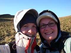
So we set off back up the path again! By now the rain had started, but we carried on heading towards the top. The rain then started coming sideways and it was stinging our faces. Scott and Molly seemed to be unfazed by the whole thing and went on up ahead, whilst Helen, Niki and I took it slowly with a few stops to catch our breath.
We eventually got to the top but we were all by now wet and cold, we headed straight back down again. The decsent via this route is pretty "hairy" quite steep steps that you have to take very carefully. We passed some people who were doing the 3 Peaks that day!!! My god we were wet and miserable but to have already done Pen-y-Ghent and Whernside and still to have to do Inglebrough in the sideways cold rain, I really didn't envy them.
When we got to the farm at the bottom, Helen started to look worse for wear. We headed on the path towards the Hill Inn, but we thought it may be about 2 miles. Helen got her head down and didn't speak to anybody, she was in the zone and had to get back asap.
When we hit the road at the Inn, we still had to get back to the first Inn we passed on the way, then back to the car (another 2 miles?) On the road me and Niki got into quite a pace and Scott and Helen dropped back a bit. The further we walked the more we lost sight of them. But we thought if we once stopped we'd never start again. Plus we were cold and wet. If we got back to the car we could drive back to get the other two.
We eventually got to the car, got our wet clothes off and started driving back. When we saw Scott by himself, we thought he'd left Helen in the pub to sort herself out with a glass of wine. However, he told us that she'd got sat in front of the fire and couldn't stop shivering so the landlady told her to get upstairs and get a bath!!! So we took Scott back to the pub where he waited inside for Helen. We waited in the car with a very wet dirty Molly (she'd have never been allowed in the pub) with the engine running to get warm. A dry clean Helen and a wet cold Scott, came out about 20 minutes later and off we went home.
A long wet day, a 9 mile walk turned into about a 14 miles walk. We're goint to check in an official route guide to see if we followed the actual 3 Peaks route, or if we still need to find that infamous footpath.
No comments:
Post a Comment